After spending countless nights stargazing with bulky star charts that tore in the wind, I discovered the magic of portable star maps. These compact, durable celestial guides revolutionized my astronomy hobby, letting me navigate the night sky anywhere from mountain camps to dark sky reserves.
How to make DIY portable star maps is simpler than you might think. With basic materials costing $15-40 and 2-4 hours of your time, you can create a personalized celestial navigation tool that withstands weather, folds to pocket size, and shows the exact stars visible from any location on any date.
Creating your own portable star map combines astronomy knowledge with practical crafting skills. I’ve tested five different methods over the past three years, from simple paper versions to waterproof vinyl designs that survived desert camping trips and rainy astronomy outings. The best part? You don’t need artistic skills or expensive equipment to make professional-quality star maps that rival commercial options.
This guide will walk you through everything you need to know: finding precise star coordinates, choosing weather-resistant materials, and creating foldable designs perfect for travel. Whether you’re making a gift for a fellow astronomy enthusiast or building your personal stargazing toolkit, these techniques will give you a reliable, portable star map that lasts for years.
Essential Materials and Tools
Before diving into star map creation, gather your supplies. The materials you choose determine durability and portability. I learned this the hard way when my first paper map disintegrated during an unexpected rain shower.
✅ Pro Tip: Start with the paper method to practice, then advance to waterproof materials once you’re comfortable with the process.
Weather-Resistant Base Materials
- Waterproof Paper ($15-25/pack): Rite in the Rain or TerraSlate paper withstands moisture and tearing. I use 32lb weight for optimal durability.
- Vinyl Sheets ($10-15): Craft vinyl creates truly waterproof maps. Choose matte finish to reduce glare when using with red light.
- Tyvek Material ($20-30): This tear-resistant material folds countless times without damage. Ideal for pocket-sized maps.
- Laminated Cardstock ($5-10): Budget option that offers moderate water resistance. Self-laminating sheets work well for field repairs.
Marking and Drawing Tools
- Archival Ink Pens ($8-12): Pigma Micron pens in sizes 005, 01, and 03 create different star magnitudes. Choose waterproof, fade-resistant ink.
- Glow-in-the-Dark Paint ($5-8): Adds nighttime visibility without ruining night vision. Apply sparingly to major stars only.
- White Gel Pen ($3-5): Excellent for adding constellation lines on dark backgrounds.
- Metallic Markers ($6-10): Silver or gold markers show well under red light and add visual appeal.
Portable Design Tools
- Compass with Ruler ($10-15): Essential for accurate coordinate plotting. Look for compact models under 5 inches.
- Protractor ($5-8): Small plastic protractors work fine for star position angles.
- Folding Bone ($5-10): Creates crisp, lasting folds in paper and cardstock.
- Carrying Case ($8-15): Small waterproof pouch or map tube protects your creation during transport.
Optional Enhancements
- Red LED Keychain ($3-5): Preserves night vision while reading your map in the field.
- Clear Contact Paper ($10-15): Adds waterproofing to paper maps without bulk.
- Corner Rounds ($5-8): Prevents corners from catching and tearing during use.
Finding Your Star Coordinates
Accurate star positions form the foundation of any usable star map. I’ve spent hours comparing different software options, and some are definitely better than others for portable map creation.
For most locations, you’ll need latitude, longitude, and the specific date/time you want to map. Remember to convert your local time to UTC – most astronomy software uses this standard. A common mistake I see beginners make is using their current time instead of the target observation time.
Free Software Options
| Software | Best For | Export Options | Learning Curve |
|---|---|---|---|
| Stellarium | Detailed star charts | PDF, PNG, SVG | Medium |
| Your Sky (Fourmilab) | Quick generation | GIF only | Easy |
| Heavens-Above | Live sky view | Screenshot only | Easy |
| Cartes du Ciel | Professional maps | Multiple formats | Hard |
Step-by-Step Coordinate Research
- Determine Your Target Coordinates: Use Google Maps or GPS to find exact latitude/longitude. Precision matters – even small errors affect star positions.
- Choose Your Date and Time: For gifts, use meaningful dates (birthdays, anniversaries). For personal use, create maps for each season’s prime viewing times.
- Convert to UTC: Add or subtract hours based on your timezone. For example, EST becomes UTC-5. Daylight saving requires additional adjustment.
- Generate Your Star Map: Input coordinates into your chosen software. Adjust settings to show magnitude 5-6 stars for optimal detail without overcrowding.
- Export and Print: Save as high-resolution PNG (300 DPI minimum) or PDF. Test print on regular paper first to verify scale and clarity.
⏰ Time Saver: Bookmark your location in star map software to skip coordinate entry for future maps of the same area.
Mobile App Solutions
For field verification, mobile apps provide excellent supplements to your physical map. Popular options include SkyView Lite, Star Walk 2, and Stellarium Mobile. These astronomy apps help double-check your work and offer real-time sky identification when you’re stargazing.
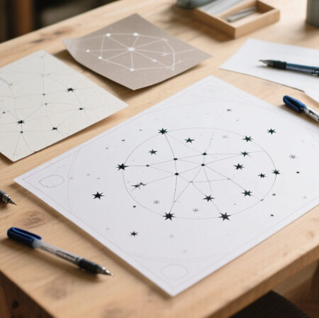
Method 1: Paper-Based Portable Star Map
This beginner-friendly method creates a durable, foldable star map perfect for casual stargazing and gift-giving. I created my first portable star map using this technique, and it still holds up after three years of regular use.
Step 1: Prepare Your Base
Start with waterproof paper or heavy cardstock (65lb minimum). Cut to 8.5×11 inches for standard printing, or trim to 8×10 inches for a more portable size. If using regular paper, apply clear contact paper to both sides before beginning – this crucial step adds water resistance and durability.
Step 2: Transfer the Star Pattern
Place your printed star map under the prepared paper. Use a light table or tape both sheets to a window for easy tracing. With your 005 pen, mark each star position with a tiny dot. The key here is precision – even small position errors affect accuracy when navigating.
For different star magnitudes, use different pen sizes:
– Brightest stars (magnitude 0-1): 03 pen
– Medium stars (magnitude 2-3): 01 pen
– Faint stars (magnitude 4-5): 005 pen
This variation helps distinguish between visible stars when viewing in low light conditions.
Step 3: Add Constellation Lines
Using your white gel pen or thin silver marker, connect the stars to form constellation patterns. Keep lines light and subtle – heavy lines obscure the stars. I learned to draw constellation lines in segments, leaving small gaps at star positions, which creates a cleaner, more professional appearance.
Step 4: Create the Folding Pattern
This is what makes your map truly portable. The magic fold creates a compact, pocket-sized design that’s easy to handle in the field:
- Fold the paper in half horizontally
- Unfold and fold in half vertically
- Fold each corner to the center point
- Finally, fold in half along the original horizontal crease
Practice this folding pattern on scrap paper first. The final result should be a small square (approximately 4×4 inches) that unfolds smoothly to reveal your complete star map.
Step 5: Add Field References
Include essential reference information in the margins:
– Your latitude and longitude coordinates
– Date and UTC time the map represents
– Cardinal directions (N, S, E, W)
– A small scale indicator
– Magnitude key showing star brightness levels
These details transform your star map from a pretty picture into a functional navigation tool.
Step 6: Apply Protective Coating
If you didn’t use waterproof paper, now’s the time for protection. Apply clear packing tape or clear contact paper to both sides. For corners, use circular patches to reinforce stress points. This step dramatically extends your map’s lifespan – my untreated maps lasted only 2-3 outings, while protected versions endure for years.
Method 2: Waterproof Vinyl Star Map
For serious outdoor use, vinyl creates an indestructible star map that handles rain, humidity, and rough handling. This method requires more patience but produces professional results that commercial services charge $50+ for.
Step 1: Prepare the Vinyl Surface
Clean your vinyl sheet with rubbing alcohol to remove any oils or residues. This step ensures better ink adhesion. Let it dry completely before proceeding – any moisture will cause the ink to bead and run.
Step 2: Prime the Surface
Apply a thin layer of acrylic primer specifically designed for vinyl. This creates a surface that accepts permanent ink without smudging. Use broad, even strokes with a foam brush. Let it dry for 30 minutes to an hour.
Vinyl Priming: A preparatory coating that creates a receptive surface for permanent ink on non-porous materials like vinyl or plastic.
Step 3: Transfer Your Star Map
There are two effective transfer methods:
Method A: Direct Drawing
If you have a steady hand, draw directly onto the primed vinyl using your archival pens. Start with pencil guidelines, then trace with permanent ink. This method gives the most authentic, hand-drawn appearance but requires confidence and precision.
Method B: Transfer Paper
Place graphite transfer paper between your printed star map and the vinyl. Trace the star positions with a ballpoint pen. The graphite transfers your design to the vinyl surface, creating perfect guides for inking.
Step 4: Ink the Stars
Using your archival pens, carefully ink the transferred star positions. Start with the brightest stars using your 03 pen, then work down through the magnitudes. This systematic approach prevents accidentally using the wrong size for key reference stars like Polaris or Sirius.
Step 5: Seal the Design
Apply two thin coats of clear acrylic spray sealer. Hold the can 12 inches from the surface and use sweeping motions. Let the first coat dry for 20 minutes before applying the second. This sealing process makes your vinyl star map completely waterproof and resistant to smudging.
Step 6: Create a Carry System
Vinyl maps benefit from a dedicated carry system. Create a simple tube from a mailing tube or invest in a small map case. Add a wrist strap from paracord – it’s surprisingly useful when you’re juggling stargazing gear in the dark.
Making Your Star Map Travel-Ready
Portability goes beyond just folding your map. After testing dozens of carrying methods on camping trips and astronomy outings, I’ve found several features that make field use much more convenient.
Compact Folding Patterns
Try the “accordion fold” for long, thin maps that show more sky area. Fold in 2-inch sections alternating directions, creating a compact strip that fits easily in a pocket. This pattern allows quick unfolding and refolding, even with gloves on.
Weatherproofing Techniques
Beyond using waterproof materials, consider these enhancements:
- Apply silicone seam sealer to fold lines for extra protection
- Add grommets to corners for tying to gear during windy conditions
- Create a simple pouch from waterproof nylon material for storage
Field Reference Additions
Include these practical elements for outdoor use:
– A small ruler printed along one edge for measuring distances
– Common asterisms marked with different symbols
– Seasonal indicator marks showing which constellations are visible each month
– Emergency navigation basics (finding north using Polaris)
Customization and Personalization
While functionality is key, personal touches make your star map uniquely yours. For gifts, these details transform a practical tool into a meaningful keepsake that captures a specific moment in time.
Meaningful Date Marking
Highlight the date and location that inspired the map. I use a small star symbol to mark the observation point, with the date written in astronomical format (YYYY-MM-DD). This creates a time capsule of the sky from a special moment.
Color Coding System
Develop a color scheme that suits your needs:
– Red for deep-sky objects visible with binoculars
– Blue for planets (if they appear in your date range)
– Green for navigation markers
– Yellow for your personal favorite constellations
Themed Variations
- Anniversary Gift: Include the wedding date location with constellation connecting lines forming heart shapes around key stars
- Birth Chart: Mark the sun, moon, and planetary positions from a birth date
- Adventure Log: Leave space for notes and sketches from each stargazing session
Using Your Star Map in the Field
A well-made star map becomes intuitive with practice. I’ve developed techniques that help beginners read their maps efficiently, even in challenging conditions.
Reading Technique
Hold your map overhead, oriented to match the sky. Red light preserves night vision while allowing you to see the details. Start with bright, recognizable constellations like the Big Dipper or Orion, then use these as anchors to locate fainter patterns.
Maintenance in the Field
If your map gets wet, shake excess water and lay it flat to dry. Never fold a wet map – this creates permanent creases and weak points. For vinyl maps, a quick wipe with a microfiber cloth restores clarity.
Building Observation Skills
Use your map to track seasonal changes. Notice how constellations shift positions throughout the year. Keep a log of new objects you find using your map as a guide. This practice turns casual stargazing into a rewarding hobby of celestial discovery.
Common Problems and Solutions
Even with careful preparation, issues can arise. Based on my experience and community feedback, here are solutions to the most frequent challenges:
Accuracy Issues
Problem: Stars don’t match the sky exactly.
Solution: Check your UTC conversion and coordinate input. Small errors here create significant position discrepancies. Also verify your software’s default settings – some show different star catalogs or magnitude limits.
Durability Problems
Problem: Map tears at fold lines.
Solution: Reinforce folds with clear packing tape on both sides before initial folding. For existing maps, apply flexible fabric tape to stress points.
Visibility Challenges
Problem: Can’t read the map in the dark.
Solution: Use a red LED light with adjustable brightness. Avoid white light which ruins night vision. Consider adding phosphorescent paint to major navigation stars for quick orientation.
Storage and Transport
Problem: Map gets damaged in backpack.
Solution: Create a rigid protective sleeve from cardboard covered in waterproof fabric. Store flat when possible, or use a dedicated map tube for curved storage.
Frequently Asked Questions
What software is best for star charts?
Stellarium offers the best balance of features and ease of use for most users. It’s free, provides accurate star positions down to magnitude 6, and exports in multiple formats. Your Sky by Fourmilab is the quickest option for simple maps, while Cartes du Ciel serves advanced users needing professional-grade accuracy.
What is the best star chart for beginners?
Paper-based star maps with bright, major constellations work best for beginners. Start with seasonal charts showing only 8-10 easy-to-identify patterns like the Big Dipper, Orion, and Cassiopeia. The magic fold pattern makes these maps portable and less intimidating than complex all-sky charts.
Is a star map a good gift?
Star maps make exceptional gifts for anniversaries, birthdays, and memorials. They capture a meaningful moment by showing the exact sky from a special date and location. When personalized with handwritten notes and crafted thoughtfully, they become cherished keepsakes that combine scientific accuracy with emotional significance.
How can I make my star map glow in the dark?
Apply phosphorescent paint sparingly to magnitude 2-3 stars using a fine-tipped brush. Test on scrap material first – too much glow paint creates a blurry effect. Let the paint cure for 24 hours before exposing to light. Yellow-green glow provides the best visibility without compromising night vision adaptation.
Can star maps be used for actual navigation?
Yes, portable star maps can serve as reliable navigation tools when paired with basic knowledge. They excel at finding cardinal directions using Polaris, determining approximate latitude, and time estimation based on star positions. However, they complement rather than replace GPS and modern navigation tools.
How do I choose between paper and vinyl materials?
Paper works well for beginners, gifts, and occasional use. It’s easier to work with and less expensive. Choose vinyl for serious outdoor use, frequent stargazing, or harsh weather conditions. Vinyl maps cost more initially but last indefinitely with proper care, making them better long-term investments.
Final Recommendations
Creating DIY portable star maps combines science, craft, and personal expression into a rewarding project. Start with the paper method to build confidence, then advance to waterproof materials as your skills develop. Remember that accuracy matters more than artistic perfection – a simple but correct star map serves better than a beautiful but inaccurate one.
These portable celestial guides have enhanced my stargazing experiences tremendously. They’ve helped me navigate unfamiliar skies, share astronomy with others, and capture meaningful moments in the stars. Whether you’re crafting for personal use or creating heartfelt gifts, the techniques in this guide will help you produce durable, accurate star maps that bring the night sky within reach, anywhere your adventures take you.
For more DIY astronomy projects and to enhance your stargazing setup, explore our related guides and tutorials. The night sky awaits your discovery.